- USLE
- Equation
- Soil Selection
- R Factor
- K Factor
- LS Factor
- C Factor
- Results
- P Factor
 The USLE can alert soil managers to potential erosion hazards, identify factors responsible for excessive erosion, and aid in selecting of appropriate conservation practices. Each factor affecting erosion can be changed individually to illustrate its impact. This version of the USLE is applicable for Nebraska. Note: Factors other than those considered in this equation can affect actual erosion
loss.
The USLE can alert soil managers to potential erosion hazards, identify factors responsible for excessive erosion, and aid in selecting of appropriate conservation practices. Each factor affecting erosion can be changed individually to illustrate its impact. This version of the USLE is applicable for Nebraska. Note: Factors other than those considered in this equation can affect actual erosion
loss.
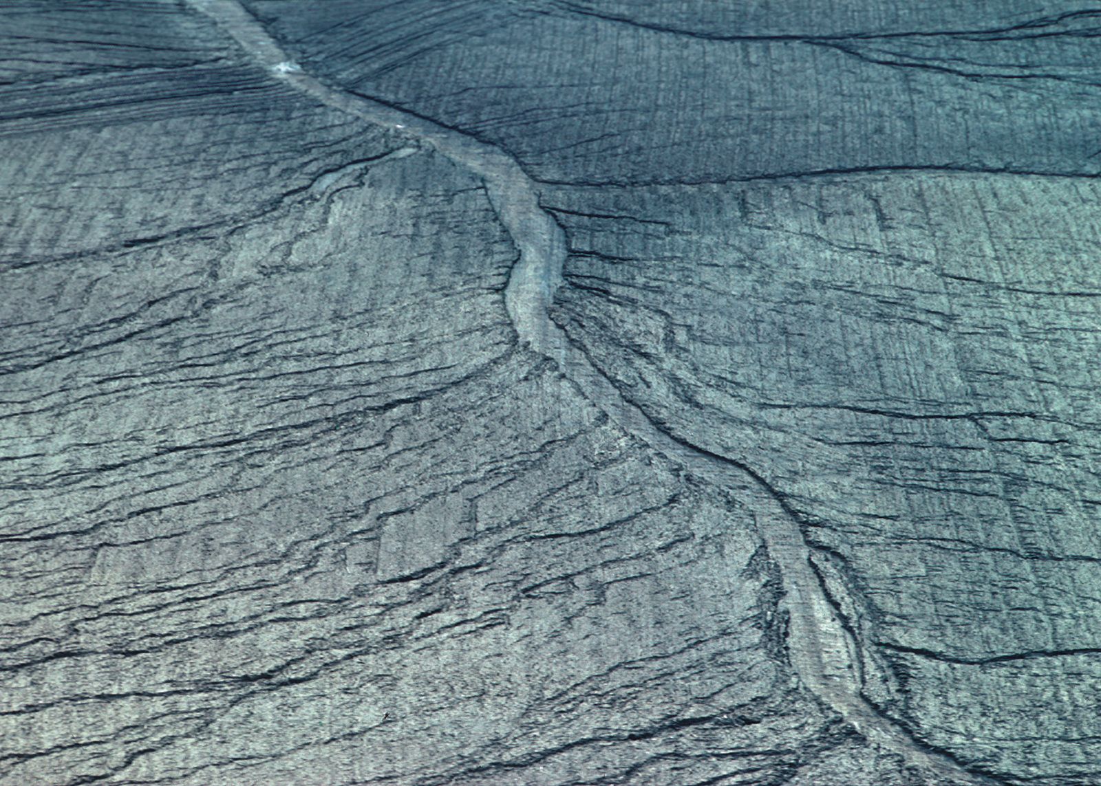
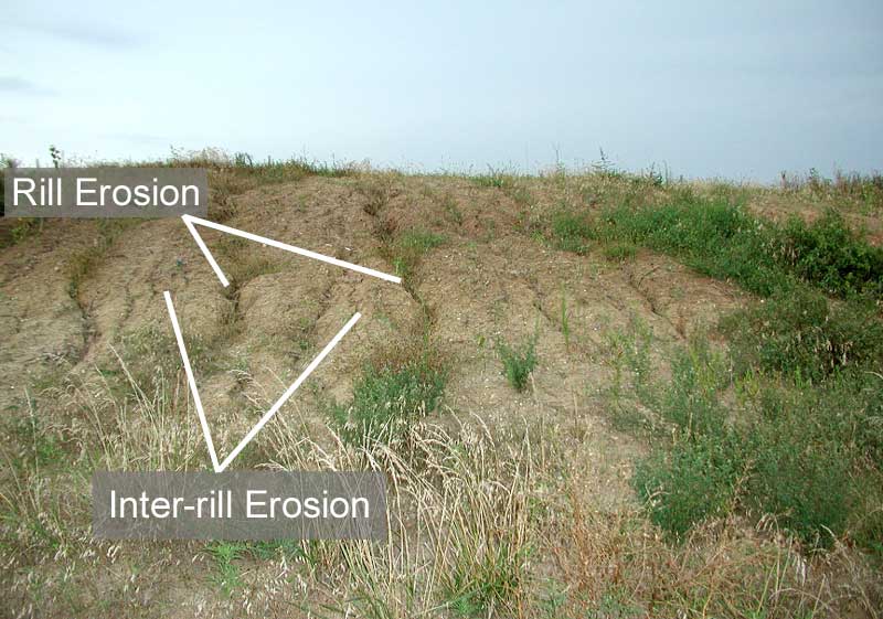
The Universal Soil Loss Equation predicts soil loss from sheet and rill types of water erosion based on site characters and management inputs. The USLE predicts if erosion will exceed a "tolerable" rate. Conservation hints and explanations of equation factors help users understand soil erosion processes and their control.


M. Mamo, T. Kettler, Fei Yu, R. Gibson
The Universal Soil Loss Equation is: A = RxKxLSxCxP
where:A - Predicted soil loss (tons per acre per year)
R - Rainfall and runoff factor
K - Soil erodibility factor
LS - Topographic factor
C - Crop and cover management factor
P - Conservation practice factor
Soil loss in tons/acre/year, and is the product of multiplying each factor’s numerical value. By changing one factor at a time each factor’s influence on the total erosion can be shown.
In this application the amount of soil loss for the selected management and conservation practices is computed and compared to the tolerable soil loss (tons/ acre/year) for a selected soil type. This value is commonly referred to as "T"
The first step in the process of calculating soil erosion is to select a soil type. Use the color coded map of Nebraska below to identify the soil type of the location you are interested in. The colors represent major soil associations dominant in an area. Use the number in the center of the colored area to select the soil type for the area of interest from the list.
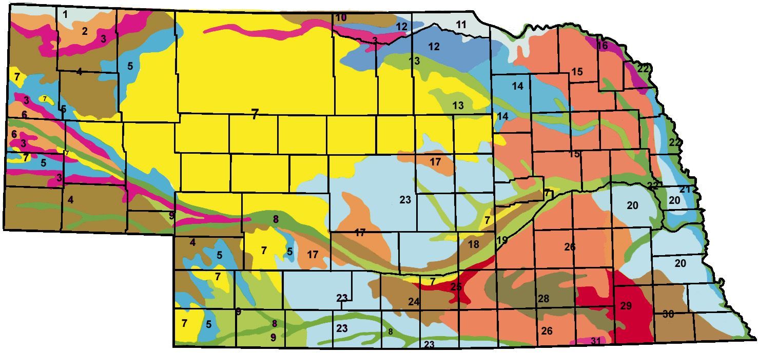
Select Number for the area of interest from the drop down below
Associated Soil Type
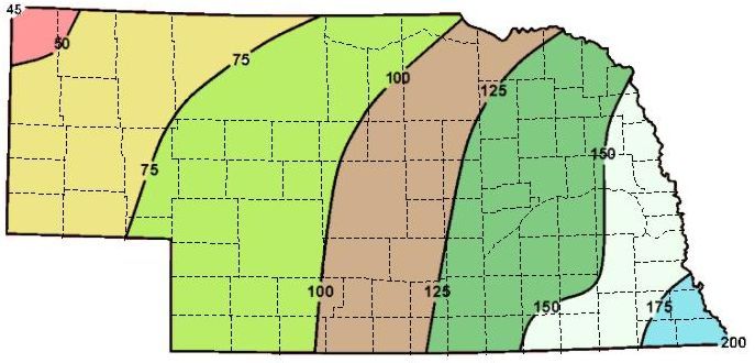
Extrapolate an R value for your site from the region averages shown in the picture
Please enter a value between 40 and 55
Soil Type Selected :---
K Factor :---
T Value :--- Tons/Acre
R Factor :---
feet
LS Factor is : ------
| Current Crop and Cover Managment choices | Adjustment |
|---|---|
| Cropping System : --for-% cover | -- |
| Tillage Effect:-- | -- |
| Expected Yield : -- | -- |
| Previous crop : -- |
| Select a cropping sequence | |
| What tillage has been used on the site? | |
| Percentage of soil surface covered by residue | |
| Expected yield: | |
| Previous crop? | |
| Adjusted C Factor | --- |
| Soil Type : -- | R : -- |
| Slope Length : -- | K : -- |
| Slope Steepness : -- | LS : -- |
| Crop : -- | C : -- |
| Cover : --% | P : -- |
| Practice : -- | |
| Predicted Soil Loss A = | |
| Tolerable Soil Loss T = tons/acre |
| Current erosion control practice | Adjustment |
|---|---|
| Unadjusted P-Factor | 1 |
| Terraces for | |
| Adjusted P-Factor |
| Which conservation practice is used |
Strip cropping reduces erosion more than contouring |
| Which terrace if any is used? |
Closed terraces reduce erosion more than open terraces |
| Terrace Interval (Omit if terrace is not used) |
Short intervals between terraces reduce erosion more than wide |